




5. L2b Products Format Overview#
The BIOMASS Above Ground Biomass L2b product is a folder containing a collection of information, grouped together into files referred to as data sets, and data sets are collected and grouped into several sub-folders in order to achieve a physical tree forming a complete product.
The kinds of datasets are the same of L2a products, i.e., the Measurement Data Sets (MDS), the Annotation Data Sets (ADS) and the Representation Data Sets (RDS); the only difference from L2a is the absence of a “Measurement folder” in order to keep the output structure simpler and the consequent presence of MDS images and additional annotations at root level, together with the main product header.
The declination and customisation of this format structure for BIOMASS Above Ground Biomass L2b product is summarised in the following table. A typical product contains:
a main product header, an XML file including high-level information about the product origin, structure and main metadata;
Above Ground Biomass image MDS, including the Above Ground Biomass image binary raster data and the quality layer, organised in two Cloud Optimized GeoTIFF (COG) files;
BPS_FNFimage annotation: this is the mask applied; if the L2b FD product is provided as input,BPS_FNFis the CFM pre-computed contained in L2b FD product [AD8], otherwise it is the FNF from L2a annotation LUT. In a Cloud Optimized GeoTIFF (COG) file;Heat Map annotation, a map of integers which stores, pixel wise, how many L1c images have been used to compute each L2b pixel, in a Cloud Optimized GeoTIFF (COG) file;
main annotation ADS, including the properties and characteristics of the measurement data or how the measurement data was generated, stored in a single XML file;
STAC metadata ADS (see Section 3) ;
quick-look ADS, including an averaged and decimated previews of measurement MDS;
Overlay ADS, for viewing the Quick-look ADS in any application that supports KML format (like, e.g., Google Earth or GIS applications);
XML schemas RDS, including the schemas needed for all the XML files included in the product.
No need for Look-Up Tables (LUT) ADS in L2b products.
No Data Value
L2b Data Sets pixels will have a no data value of -9999.0 (float32) or 255 (ubyte) depending on data type, where the input L2a pixels are invalid and for each pixel discarded by the algorithm.
The value is reported in all the MDS COG metadata (GDAL_NODATA tag, see Tab.2) and in the Raster Image DSR (noDataValue element, see 6.3.1.2).
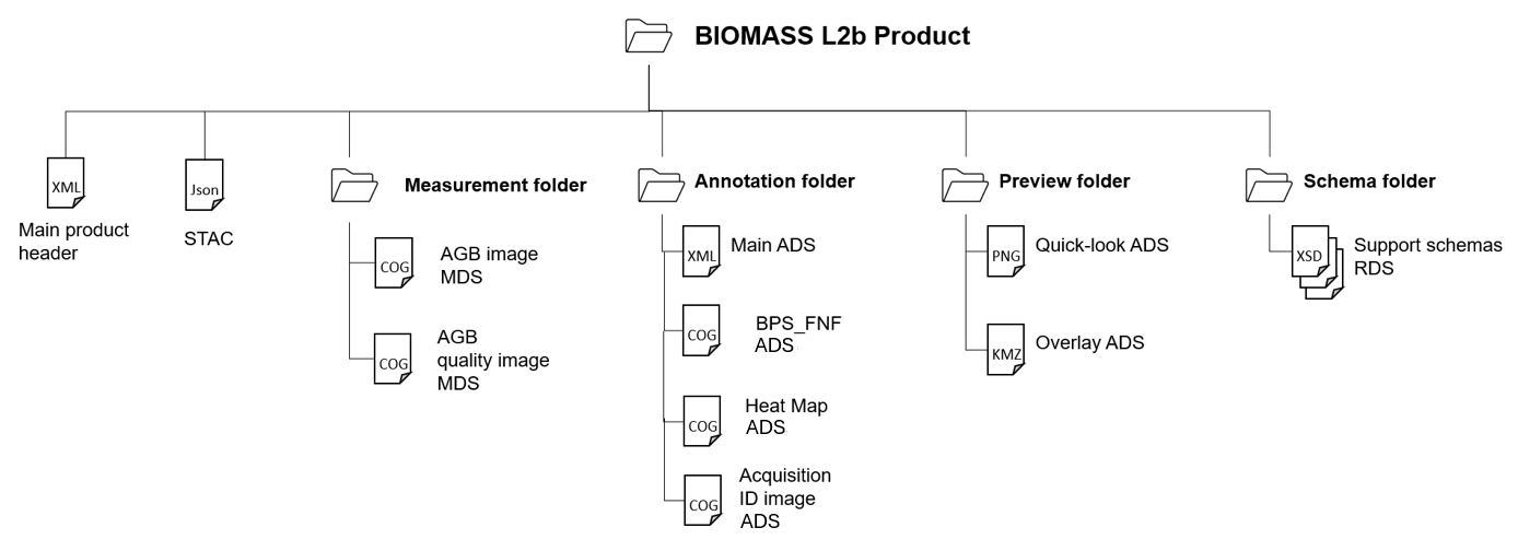
Fig. 18 — Above Ground Biomass L2b products structure
Table 40 — Above Ground Biomass L2b products structure
File / Folder |
Cardinality |
Format |
Description / Content |
|---|---|---|---|
BIOMASS Above Ground Biomass L2b Product |
Folder |
||
∟ main product header |
1 |
XML |
Main product header |
∟ STAC |
1 |
JSON |
STAC (https://stacspec.org) metadata. |
∟ measurement |
Folder |
||
∟ Above Ground Biomass |
1 |
COG |
Above Ground Biomass image MDS |
∟ Quality |
1 |
COG |
Quality image MDS |
∟ annotation |
Folder |
||
∟ main |
1 |
| |
Main ADS, including: Product DSR Raster Image DSR Input information DSR Processing parameters DSR |
∟ |
1 |
COG |
FNF or CFM mask |
∟ Heat Maps |
3 |
COG |
Three Heat Maps in a single COG, one for each layer: Heat Map Heat Map reference Heat Map additional reference |
∟ Acquisition ID Image |
1 |
COG |
Pixel wise binary indicator of contributing images |
∟ preview |
Folder |
||
∟ quicklook |
5 |
PNG |
Quick-look ADS, for: AGB (from measurement) AGB quality (from measurement) Heat Map (from annotation) Heat Map reference (from annotation) Heat Map additional reference (from annotation) |
∟ overlay |
5 |
KML |
Overlay ADS, for each quicklook |
∟ schema |
Folder |
||
∟ main |
1 |
XSD |
RDS |
∟ L2a, L2b common |
1 |
XSD |
RDS |
∟ common |
1 |
XSD |
RDS |
∟ |
1 |
XSD |
RDS |
5.1 Product format definition guidelines#
Refer to sec. 3.1.
5.2 Naming convention#
The BIOMASS L2b product and all data sets files naming are addressed and described in detail in [AD2].
The naming of the products directories is here proposed following the main points in [AD2]:
<MMM>_<TTTTTTTTTT>_<P>_G<CC>_T< TTTTTTT>_B<BBB>_<BB>_<DDDDDD>
where:
<MMM>: Satellite ID;<TTTTTTTTTT>: Product Type/File Type, i.e.:FP_AGB_L2B: Above Ground Biomass L2b product;
<P>: Mission phase identifier;<CC>: Global Coverage identifier;<TTTTTTT>: Tile number of the product, the seven digits are[N|S]aa[E|W]bbb,
where:
- `N|S:` stands for North or South;
- `aa:` latitude in two digits padded with zeros (at 0º N or S are both valid);
- `E|W:` stands for East or West;
- `bbb:` longitude over 3 digits padded with zeros ( at 0º E or W are both valid);
<BBB>: Basin literal identifier of the product (string);<BB>:Baseline Identifier;<DDDDDD>: Compact creation date.
The internal files in the product inherit the same naming convention, with the following changes:
capital letters conversion to lowercase;
“Baseline Identifier” and “Compact Creation Date” naming parts removal, except for Main Product Header file;
addition of a dataset type depending suffix and extension, i.e.:
*.xmlfor main product header;*_i_[agb|agb_std_dev].tifffor image MDS;*_annot.xmlfor main ADS;*_i_[acquisition_id_image|heatmap|bps_fnf].tifffor images in annotations;*_[agb|agb_std_dev|hm_hm_additional_reference|hm_reference]_ql.pngfor quick-look ADS;*_[agb|agb_std_dev|hm_hm_additional_reference|hm_reference]_map.kmlfor overlay ADS;.xsdfor support schemas RDS;*.jsonfor STAC.
For basins, the following notation is used:
• South America tropical: 100
• South America temperate: 200
• Africa tropical/temperate: 300
• Asia temperate: 400
• Asia tropical: 500
• Oceania tropical/temperate: 600
• Exclusion zone: 700